Hells Canyon (Washington / Oregon / Idaho)
About
What It Is
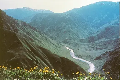
Hells Canyon National Recreation Area (HCNRA) spans the border of northeastern Oregon and western Idaho, carved by the Wild and Scenic Snake River. Congress designated the Hells Canyon Wilderness within it in 1975; that wilderness unit covers 217,927 acres in total, with roughly 83,811 acres on the Idaho side and the remainder on the Oregon side [2]. The area is managed primarily by the U.S. Forest Service, with approximately 940 acres under Bureau of Land Management jurisdiction [2]. The gateway communities of Clarkston and Asotin in Washington, along with several Idaho and Oregon towns, lie within about one hour of the recreation area [1].
The canyon is split into two distinct halves by the Snake River, and approximately one-third of the HCNRA is designated Wilderness [2]. The Idaho side encompasses the Seven Devils mountain range, while the Oregon side features rocky slopes, grassland benches, stringer canyons, and groves of Douglas fir and ponderosa pine at higher elevations [2]. The Wilderness stretches roughly 31 miles south from Pittsburg Landing along the Snake River [2].
Activities & Experiences
Visitors can float or powerboat the Wild and Scenic Snake River, launching from sites such as the Hells Canyon Boat Launch and Pittsburg Landing Boat Launch [1]. Hiking and equestrian travel are available on rugged, steep terrain throughout the Wilderness, including two National Trails: the Western Rim/Summit Ridge Recreation Trail at upper elevations and the Nez Perce National Historic Trail near the Snake River [2]. Wildlife viewing opportunities include Rocky Mountain elk, bighorn sheep, mule deer, and chukar [2].
Historic and interpretive sites are also accessible within the recreation area, including the Kirkwood Historic Ranch and Cache Creek Ranch [1]. The Hells Canyon Creek Visitor Center provides interpretive information for those arriving by boat or road [1]. The terrain also supports self-reliant cross-country travel for experienced backcountry visitors seeking solitude [2].
Practical Access
The southern portions of the Wilderness can be reached from a trailhead at Copper Creek, approximately nine miles north of Oxbow on the Oregon side [2]. Primitive camping and restrooms are available at that access point, and no fees or permits are required for hiking in the Wilderness [2]. Boating on the Wild and Scenic Snake River requires a permit year-round; during the primary season (Friday before Memorial Day through September 10), float and powerboat permits are obtained through a lottery or reservation system on Recreation.gov, with reservations opening March 1 at 7 a.m. Pacific Time [1].
During the secondary season (September 11 through the Thursday before Memorial Day), self-issue permits are available at major launch sites [1]. Lower elevations of the canyon may be accessible year-round, while higher elevations can retain snow well into summer months [2]. Hiking conditions vary significantly by season and elevation, and many trails are unmaintained or in primitive condition [2].
Restrictions
A permit is required to float or powerboat the Wild and Scenic Snake River at any time of year [1]. Primary-season boaters must apply through the Four Rivers Lottery or reservation system via Recreation.gov; secondary-season boaters use self-issue permits at launch sites [1]. Hikers should be aware that some trails have been destroyed by flooding and not reconstructed, and all water from streams must be treated before drinking [2].
Visitors are advised to watch for rattlesnakes and ticks, particularly in warm, humid conditions or brushy terrain [2]. The canyon can be extremely hot in summer, and reliable water sources may be difficult to locate away from major tributary creeks [2].
What Makes It Distinctive
Hells Canyon is one of the deepest river gorges in North America, and its Wilderness designation since 1975 has preserved a landscape that combines dramatic canyon topography with a free-flowing Wild and Scenic river corridor [2]. The area spans three states and two federal agencies, offering an unusually diverse range of ecosystems from low-elevation grassland canyons to high-elevation mountain terrain on the Idaho side [2]. Two National Trails traverse the area at different elevations, and historic ranch sites add a cultural dimension rarely found alongside such remote wilderness [1][2].
The combination of river-based and overland access, multi-day boating routes, and genuine backcountry solitude distinguishes Hells Canyon from more developed canyon destinations [2]. The presence of the Nez Perce National Historic Trail also gives the area significant Indigenous cultural heritage context [2].
Sources
- Wallowa-Whitman National Forest | Hells Canyon National Recreation Area - Snake River | Forest Service
- Hells Canyon Wilderness Area | Bureau of Land Management
- Best months: May–July
- Typical duration: 3h
Access & fees
- boating permit
- hiking entry
- no fee (wilderness hiking)
- river permit required
Things to do
- birdwatching
- camping
- fishing (snake river)
- float boating
- hiking and backpacking
- hiking and equestrian travel
- historic ranch visits
- horseback riding
- jet boat tours on the snake river
- photography
- power boating
- powerboating
- scenic driving
- stargazing
- visit panoramic overlooks (such as hells canyon overlook)
- whitewater rafting and kayaking
- wildlife viewing
Before you go
- extreme summer heat
- trail conditions
- wildlife hazards
Amenities
- boat launches
- primitive camping and restrooms
- visitor center
Best time to visit
- higher elevations
- lower elevations year-round
Events & seasons
- four rivers lottery (float)
- self-issue river permit
Features
- 217,927-acre wilderness
- deepest river gorge
- national historic trail
- national recreation trail
- seven devils mountain range
- three-state canyon
- wild and scenic snake river
- wilderness designation
Nearby
- gateway communities
- gateway towns (idaho)
- gateway towns (washington)
Good to know
- boating reservations open
- primary boating season
- secondary boating season
- southern trailhead access
- treat all water