Hells Canyon (Washington / Oregon / Idaho)
Nature in The Palouse & Blue Mountains, Washington, United States
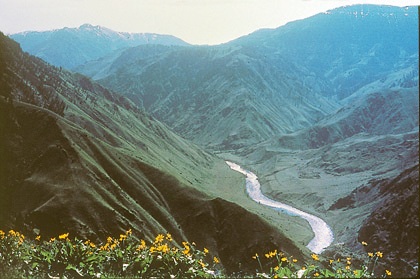 Public domain
- Best months: May–July
- Elevation gain: 0 m
- Open weeks per year: 13
Access & fees
- no fee (wilderness hiking) (fee: none · permits: not required for hiking)
- river permit required (booking: Recreation.gov from March 1 · applies to: float and powerboat)
Things to do
- birdwatching
- camping
- fishing (snake river)
- float boating (permit: required year-round · primary season lottery: Recreation.gov)
- hiking and backpacking
- hiking and equestrian travel (terrain: steep, primitive trails)
- horseback riding
- jet boat tours on the snake river
- photography
- powerboating (permit: required year-round · primary season lottery: Recreation.gov)
- scenic driving
- stargazing
- visit panoramic overlooks (such as hells canyon overlook)
- whitewater rafting and kayaking
- wildlife viewing — bighorn sheep, deer, elk, eagles
Amenities
- boat launches (sites: Hells Canyon, Pittsburg Landing)
- primitive camping and restrooms (location: Copper Creek trailhead)
- visitor center (name: Hells Canyon Creek Visitor Center)
Best time to visit
- lower elevations year-round (window: year-round) — higher elevations snow into summer
Events & seasons
- four rivers lottery (float) (opens: March 1, 7am Pacific · window: Friday before Memorial Day – Sep 10)
- self-issue river permit (window: Sep 11 – Thursday before Memorial Day)
Features
- 217,927-acre wilderness (designated: 1975 · managing agency: primarily US Forest Service)
- seven devils mountain range (location: Idaho side of wilderness)
- wild and scenic snake river (role: bisects canyon, Oregon–Idaho border)
Nearby
- gateway towns (idaho) (drive: within 1 hour · towns: Riggins, Lewiston, Grangeville, Whitebird, Lucille)
- gateway towns (washington) (drive: within 1 hour · towns: Clarkston, Asotin)
Good to know
- southern trailhead access (location: Copper Creek, ~9 miles north of Oxbow, Oregon)